Abingdon’s Boundaries
Land boundaries are of many types – each created for a different purpose, such as ownership, taxation, ecclesiastical control, access to trading privileges, parliamentary representation, and so on.
There are at least four distinct administrative areas that are described by the use of the name Abingdon:
- The borough of Abingdon as defined by a charter of 1556 and later extensions.
- An ecclesiastical parish, formed in 1894 by the amalgamation of the parish of St Nicolas with part of St Helen’s. In 2013 this was divided into the parishes of Abingdon-on-Thames and Abingdon North.
- The civil parish, used for the purposes of the census.
- The parliamentary constituency – Abingdon (borough) was given the right to appoint a member of parliament under the 1556 charter – until the Distribution of Seats Act, 1885.
This article is concerned with the first of these, the 1556 charter boundary.
Land boundaries are of many types – each created for a different purpose, such as ownership, taxation, ecclesiastical control, access to trading privileges, parliamentary representation, and so on. Although areas defined by boundaries have common features – every spot in the country is included, and no spot can be in two areas – the proliferation of different boundaries for different purposes can mean that spots can appear to be in two places at the same time. For example, an interesting aspect of Abingdon’s boundary is that before 1974 when it was in Berkshire, its own borough boundary extended a short way across the river into Oxfordshire.
There are at least four distinct administrative areas that are described by the use of the name Abingdon:
- The borough of Abingdon as defined by a charter of 1556 and later extensions.
- An ecclesiastical parish, formed in 1894 by the amalgamation of the parish of St Nicolas with part of St Helen’s. In 2013 this was divided into the parishes of Abingdon-on-Thames and Abingdon North.
- The civil parish, used for the purposes of the census.
- The parliamentary constituency – Abingdon (borough) was given the right to appoint a member of parliament under the 1556 charter – until the Distribution of Seats Act, 1885.
The Ordnance Survey maps from 1875 onwards show some of these boundaries and how they have changed over time. Some boundaries also have marker stones, and others are described in documents. Research is being carried out to record these and this feature article will be expanded as the results become available. At the moment we can report on the first of these, the 1556 charter boundary.
Abingdon’s Charter Boundary
Abingdon’s boundary was set out in the 1556 Charter of Incorporation for Abingdon. The land area stretched from Abingdon lock on the Thames in the east to the end of Ock Street in the west, and from the Ock in the south to Boxhill Walk in the north – see Figure 1. The built-up area at that time comprised little more than the houses in East and West St. Helen Streets, High Street, Stert Street and Bath Street. Most of the land within the borough boundary was farmland, orchards and market gardens.

Figure 1. Abingdon’s boundaries as proposed in 1831 when they were still almost the same as those in the 1556 charter.
After the dissolution of the Abbey in 1538 and the Fraternity of the Holy Cross in 1547 Abingdon lacked institutions to look after the poor and sick and educate the population. The charter granted by Phillip and Mary in 1556 set out Abingdon’s boundaries very clearly and laid down the responsibilities of a new body corporate – the Mayor, Bailiffs and Burgesses – that had powers to act within them. The boundaries were important to show where authority held control and the area covered by any decisions made by the new corporation.
The custom of walking the boundary of the Borough of Abingdon (‘beating the bounds’) was laid down in the Charter. This helped to ensure people knew where it was, as well as allowing the council to check on anyone building over or otherwise infringing on it. At some point, boundary (or meer) stones were erected to establish its line.
The ‘beating of the bounds’ was a jolly occasion and at several of the stones, buns, barrels of ale and, later, tea, were distributed. There was always a great feast for town dignitaries at the end, paid for, no doubt, by the citizens. The story of the 1880 walk is described below. The custom was re-enacted as part of the celebration of the Millennium in 2000.
The boundary as laid out in the Charter
The charter was written in Latin, but the following description of the boundary comes from an English translation thought to have been made in the seventeenth century.[1]
...that the compasse and circuit of the Borough aforesaid shall extend and stretch itselfe from the Locks aforesaid, called the Abbey Locks, through the whole River Thames, including the same River unto the Bridge called the New Bridge built upon and over the said River of Thames, and from the aforesaid Bridge called the New Bridge including the whole of the River of Thames unto the aforesaid little Bridge of St Helene called St. Helen’s Bridge, where the said little Stream of the Ock falls unto the Thames as aforesaid, and from thence by and through the aforesaid little Stream of the Ock including the same little Stream unto the aforesaid Bridge of the Ock called the Ock Bridge, and from the said Bridge called the Ock Bridge directly by and through the publick way leading from the same Bridge to a little Close called the Trinitie Closes, and from thence by and through the Common way leading by the aforesaid little Hill called Barrow Hill unto the aforesaid Boundary and Meer Stone without the aforesaid Barres of the Bore Street, situate in the meeting together of the aforesaid two publick ways leading towards the aforesaid Borough, and from thence by and through another publick way a little turning towards the North until you come to a certain Crooked little Ditch inclining towards the East, which said little Ditch together with the aforesaid publick way includes on the right hand Fitzharris Farm and a certain piece of Arable Land called Fitzharris piece, and the Fields, Meadows and Pastures called Fitzharris Closes to the same Farm belonging and apperteyning, and from thence by another Ditch on the right hand also including a certain Close called Pykes Close unto the aforesaid Boundary and Meer Stone without the Barres of the Publick Street of the Wyneyard aforesaid, situate in the meeting together of two publick ways leading to the Borough of Abingdon aforesaid, and from the same Meer Stone by and through another publick way turning towards the East towards the River of Thames, including a certain Conventuall Close called the Convent-Close, being wholly ditched and partly hedged, and partly paled, and one little Close called the Pytenry, and from the corner of the same Close called the Pytenry through the said River of Thames including the same River unto the Locks aforesaid; and that the Soile and Land, with all the Lanes, Streets, Ways, Places, Closes and Corners whatsoever, lying and being within the aforesaid Boundaries, Meers and Limitts, shall be and shall be reputed and taken to be within the Borough aforesaid and the Liberties thereof, and all and singular Messuages, Houses, Buildings, Lands, Tenements, Grounds and Soils whatsoever within the aforesaid Meers, Boundarys, Limitts and Precincts from henceforth be and shall be reputed to be parts and parcells of the said Borough of Abingdon, now by these Presents into a Body Corporate and Politick, erected and incorporated , and it shall and may be lawful for the aforesaid Mayor, Bailiffs and Burgesses of the Borough of Abingdon aforesaid for the time being, and for their Successors to make perambulation or perambulations thereof for the true and better knowledge thereof to be had as often as it shall please them, or to them shall seem convenient, and this without any Writ or Warrant therefore of us, the Heirs or Successors of us the aforesaid Queen in this behalfe, in any manner to be had or prosecuted.
For modern readers, “the whole of the River of Thames” should be taken to mean the River from bank to bank;
“The Little Bridge of St Helen’s” was a stone bridge of seven arches, across the River Ock and the marshy ground beyond;
The “Trinitie Closes” relate to the Trinity chapel that was situated at the top of what is now Spring Road;
“Barrow Hill” must be on Faringdon Road;
“Barres” were gates;
“Bore Street” later became Boar Street and was renamed Bath Street in 1860;[2]
“Closes” were enclosed areas of land, either fenced or walled, often around a garden;
“Pytenry Close” was the Pittancery. There was an Abbey official called the Pittancer who was concerned with feeding the monks – their diet was split between the very limited amount specified in the Rule of St Benedict and the ‘pittance’ which brought it up to a level more appropriate to their status. The Pittancery Close would no doubt have provided some of the funds for this. The boundary near the Pittancery is clearly shown on the ‘Monks’ Map’ in Abingdon County Hall Museum.
The Boundary marker stones
As well as the description given above, the 1556 charter also mentions some “Boundary and Meer Stones marked with a leaden letter A”. These were (a) near Barrow Hill at the junction of Faringdon Road and Wootton Road, (b) on the ‘little bridge of St Helene’ and (c) at the junction of Radley Road and the Vineyard.
In 1880 a committee was formed to examine closely the Borough boundaries and to compare the limits set out in the charter of 1556 with the new Ordnance Survey maps. Their report to the Council refers to eight meer stones:
1. at the junction of Faringdon Road and Wootton Road (1556 charter (a))
2. opposite the Boxhill footpath ( roughly the site of John Mason School opposite Boxhill Walk),
3. under a hedge along this footpath,
4. in the triangular enclosure at the junction of Oxford and Radley roads ((c) in 1556),
5. at the gate at the north-west corner of the ferryboat field,
6. by the side of the towing path,
7. in the west wall of the iron bridge ((b) in 1556)
8. at the south west corner of Spring Road.
It seems clear that the positions of the 1556 stones were still marked in 1880 at positions 1, 4 and 7. Today, marker stones with an iron A set into them can be seen in a number of positions broadly following the charter boundary (Fig. 2). We do not know when these were erected or whether they are the stones referred to in the report. There are iron A stones now only in positions 3 and 6, but there are three others not mentioned in the list, which may of course have been moved to their present positions.
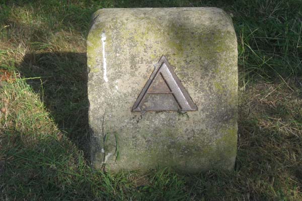
Figure 2. Boundary marker stone near Thames path
(© D Clark)
It should also be noted that the river Thames formed the southern boundary of Abingdon in the charter description. However, the 1831 map (Fig. 1) shows a red boundary set along the south bank of the river, and there are two iron boundary stones on the ‘Oxfordshire’ bank of the Thames in the area known as the Rookery opposite St Helen’s Wharf (Fig. 3). There is also a boundary stone on the south bank near Abingdon Lock (Fig. 4).

Figure 3. Stone in Rookery
(© D Clark)

Figure 4. Stone by gate at Abingdon Lock
(© D Clark)
To walk Abingdon’s Boundaries today
We recommend a route that starts at St. Helen’s Wharf. Walk down to the confluence of the Ock and the Thames. The boundary followed the Ock as far as the Ock Bridge, so begin by walking upstream to St Helen’s Mill (Fig. 5).

Figure 5. St Helen’s Mill
(© D Clark)
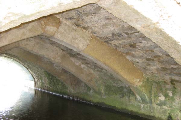
Figure 6. Ock Bridge
(© D Clark)
As this is private, you must follow the path through the churchyard to West St Helen Street, turn left and left again down a footpath behind Twitty’s almshouses to a bridge over the Ock at the start of the Ock Valley Walk. Follow this to the Drayton Road and turn right, crossing Ock Bridge – which still has its medieval arches beneath the modern carriageway (Fig. 6). At the roundabout head north to follow the boundary along Spring Road to the junction with Faringdon Road, and then turn east to the Wootton Road. From the junction, walk along Wootton Road to John Mason school where there is a boundary stone next to the bus stop. This stone is different from those with the iron A illustrated in Figure 2, and is part of a set of fifteen Parliamentary Boundary markers set out in 1870 to mark the constituency – which was not the same as the old charter boundary area.
Cross the road and walk up Boxhill Walk, The original boundary can still be traced along the line of present-day property boundaries around the back gardens of Fairfield Place and Marsh Court to Harcourt Way, where it crossed the Stert, and then around the back of 41 and 43 Harcourt Way, 1 and 3 Boxhill Walk. There is a stone with an A in a (private) garden on Bowyer Road.
From here, the boundary followed the line of the present footpath through Boxhill Wood before turning east by Pykes Close (now The Motte). At the Vineyard, turn left towards the junction of Radley Road and Oxford Road. The 1875 Ordnance Survey map shows a boundary stone on a traffic island where the mini-roundabout now is, but this has now disappeared. The charter boundary then ran along the southern edge of Radley Road, turned down Audlett Drive (formerly Barton Lane) to what is now Crabtree Place and cross the Abbey Mill Stream by the footbridge. Turn left and follow the path to the lock.

Figure 7. Stone near towpath
(© D Clark)
Cross to the Oxfordshire bank and look for the boundary stone below the lock, now used to hook the road gate open (Fig. 4). Return to Abingdon Bridge along the river bank and visit the stones at the Rookery opposite St Helen’s wharf. There is one near the towpath (Figs.2 and 7) and one further south in the thicket (Fig. 3).
The 1880 Beating of the Bounds
The charter obliged the Mayor and Corporation “for the time being and for their successors to make perambulation or perambulations thereof for the true and better knowledge thereof’.” By 1603, when Francis Little was appointed one of the “viewers of mounds and bounds” within the Borough, it was already described as “an ancient custom here used”.
Most of the references in the borough records refer to the practice in the nineteenth century. It was customary for the chamberlain to provide cakes and ale (400 cakes and 2 or 3 kilderkins of ale) to be distributed to the populace en route.[3] Afterwards the Mayor and Corporation would sit down to dinner.
It was ordered that these boundaries should be beaten on 13 August 1880. A full report of the proceedings, which had not taken place for some twenty-seven years, appeared subsequently in the local press. In addition to the mayor (William Ballard) and members of the Council, the party included the Town Clerk (Bromley Challenor) bearing the borough flag, the Sergeants-at-mace, representatives of the local constabulary, a drum and fife band and the “wandbearer” a Mr F Harris “chosen on account of his swimming abilities”. Presumably it was his duty to beat the actual boundary markers. The procession started at the council chamber and proceeded via High Street to the southwest corner of Spring Road. Here the report describes how a small boy was “bumped” against the stone by the town clerk; buns and coins were thrown.[4]
The next stop was at the corner of Faringdon Road and Wootton Road where two-ounce packets of tea, buns and a barrel of beer were distributed. At the old pound south of the Boxhill footpath several children were ‘bumped’ and rewarded with a scramble for coins. When the Boxhill ditch was reached the party discovered that the bridge had been removed and the town clerk made a valiant but unsuccessful leap across, landing knee-deep in the muddy ditch. At this juncture a short detour was taken to Fitzharris House, the home of Councillor Heber Clarke, where luncheon was taken, while the band played on the lawn.
After lunch the party continued via the workhouse, down the Oxford Road towards the next boundary stone at the railed enclosure at the junction of the Oxford and Radley Roads, where a barrel of beer and buns were distributed to the crowd. The next section of the route was via Radley Road, Barton Lane, across the railway towards the Abbey Mill stream where punts were waiting to convey the party upstream towards the meer stone near the north west gate of the ferry-boat meadow above the lock. There was a good deal of horseplay, boats colliding and duckings in the river. The journey back downstream continued past the new bathing place towards Abingdon Bridge and the Rookery where Mr A E Preston, Collector of the General District Rate, and Mr Winship, the Borough Surveyor, were both tipped into the river. A halt was made opposite Mr Steven’s boathouse while the wandbearer and the borough surveyor swam across the river, over the course of the boundary line. The next stop was St Helen’s Wharf where the official party set off for the final part of the proceedings, a boat trip up the river Ock. There were further duckings of councillors and the local police superintendent. At one point the valuable town mace was almost lost in the chaos, but it was rescued by Alderman Payne. Eventually the party reached the point at the west end of Ock Street from which the walk had started. The climax to the proceedings was the throwing of buns, money and packets of tea from the top of the County Hall. In the evening a banquet was held for the mayor, corporation and invited guests at the Council Chamber, with catering by Mrs Goddard of The Crown & Thistle.
Later boundary changes
This 1880 description suggests that there had been a slight enlargement of the municipal boundary since 1556, taking in the Workhouse on the Oxford Road and an additional area to the east of the Thames lock. In 1890 there was a proposal to enlarge the limits of the Borough significantly to incorporate the hamlet of Northcourt and to use the line of the Wilts and Berks Canal to determine the southern limit of the Borough. There was a major review of the boundaries in 1951 and in the 1970s when the built up area of Abingdon expanded to the north. With the growing pressure to build new houses around Abingdon, the boundary of the town will no doubt be pushed even further out – the story of Abingdon’s boundary will thus continue to develop.
© AAAHS and contributors 2015
[1] This translation is from Bromley Challenor Selections from the Records of the Borough of Abingdon 1555-1897, (Abingdon, 1898) who wrote that it “is said to have been the work of Mr Recorder Holt, in or about 1665” but he did not give a source for this. Town charters were continually under question in the Restoration period, and Abingdon was forced to accept a new one in 1663 which Challenor did not know about. The translation may very well have been made in connection with this, or possibly with the further changes of the 1680s.
[2] Agnes Baker (1957) in Historic Streets of Abingdon floats the suggestion that Bore derives from Borealis (north in Latin). It also seems to have been called Barrowe St. or Berrewe St. – no doubt relating to Barrow Hill.
[3] A kilderkin was a cask containing 16 gallons of ale.
[4] It is clear that the boys were subject to not inconsiderable physical discomfort during these progressions – in order to instil in them the knowledge of the correct places on the route. The wandbearer may thus have had to hit the boys as well as the markers. In Oxford the coins thrown to them on the beating of St Mary the Virgin parish bounds had been heated in a fire – they could keep the coins, if they endured the burns.

